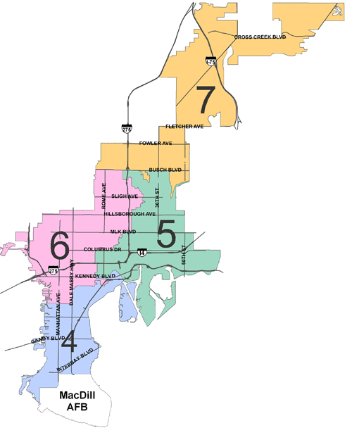
A single member district, running North from McKay Bay/Palmetto Beach, including all of Downtown Tampa, Channel District and Ybor City.
The district is bordered on the East by the City Limit Line. The district then continues South following the City Limit Line along the Tampa Bypass Canal. The district then continues West following the City Limit Line along Palm River. The district then continues South and Southwest following the City Limit Line, to the Southern tip of the port of Tampa. The district then continues North following the Western boundary of the Port of Tampa along Sparkman Channel. The district then continues West following the Southern boundary of Downtown Tampa along Garrison Channel to Platt Street. The district then meanders West along Platt Street, Southwest along Bayshore Blvd., North along Magnolia Avenue, West along Swann Avenue, North along Boulevard, West along Cleveland Street, North along Moody Avenue, West along North "A" street, North along Armenia Avenue, East along Gray Street, North along Howard Avenue, West along Interstate 275, North along Armenia Avenue, East along Columbus Drive, North along Munro Street, East along Euclid Avenue, North along Esther Street, East along Warren Avenue, North along Boulevard, East along West Street, North along Massachusetts Avenue, East along Alfred Street, North along Ola Avenue, East along Adalee Street, North along Highland Avenue, West along Plymouth Street, North along Ola Avenue, East along Woodlawn Avenue, North along Dartmouth Avenue, East along Indiana Avenue, South along Highland Avenue, east along Ohio Avenue, North along Arlington Avenue, East along Indiana Avenue, North along Florida Avenue, West along Kentucky Avenue, North along Tampa Street, East along Virginia Avenue, North along Florida Avenue, East along Dr. Martin Luther King, Jr. Blvd., North along Taliaferro Avenue, East along Ida Street, North along Nebraska Avenue, West along Clifton Street, South and Northeast along Roberta Circle, East along Clifton Street, North along 12th Street, East along Paris Street, North along 15th Street, East along North Street, North along 17th Street, West along Lambright Street S., North and East along Lambright Street N., North along 19th Street, West along Diana Street, Northwest along Escort Avenue, West along Knollwood Street, North along 17th Street, East along Sligh Avenue, North along 18th Street, Southwest along Park Circle, North across the Hillsborough River, West along the River, North along Nebraska Avenue, West along Fairbanks Street, North along Mitchell Avenue, West along Wood Street, South along Huntley Avenue, West along Waters Avenue, North along Florida Avenue, East along C.S.X. Railroad, North along Interstate 275, East along Busch Blvd., South along Brooks Street, Southeast along C.S.X railroad, West along Eskimo Avenue, South along 15th Street, East along Yukon Street, South along 17th Street, East along Waters Avenue, Southeast along Rowlett Park Drive, North along 22nd Street, East along Rampart Street, North along 22nd Street, West along Yukon Street, North along 20th Street, West along Okaloosa Avenue, North along 18th Street, East along Busch Blvd., South along 40th Street, then Northeast along the Hillsborough River to the City Limit Line finishing the district boundary.
For More Information on Neighborhood Associations in this District visit the Neighborhood and Community Relations web site or contact them at 813/274-8152