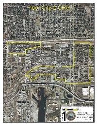
Beginning at the intersection of the Centerline of Interstate Highway 4 (State Road 400), and the Centerline of 26th Street, as shown on State of Florida - State Road Department Interstate Expressway No. 4, Section No. 10190-2417-41-14 of State Road No. 400, Hillsborough County, State of Florida State Road Department Right of Way Map; run thence Southerly along said Centerline of 26th Street, to its intersection with the Centerline of Adamo Drive; thence Westerly along said Centerline of Adamo Drive, to its intersection with the Southerly projection of the Centerline of that vacated portion of 20th Street; thence Northerly along said Centerline of said vacated portion of 20th Street, to its intersection with the Centerline of 2nd Avenue; thence Westerly along said Centerline of 2nd Avenue, to its intersection with the Centerline of 18th Street; thence Northerly along said Centerline of 18th Street, to its intersection with the Easterly projection of the Centerline of the alley in Block 65 of YBOR AND CO'S SUBDIVISION a subdivision as recorded in Plat Book 1, Page 22 of the public records of Hillsborough County, Florida; thence Westerly along said Easterly projection of Centerline and its Westerly projection to and along the Centerline of the alley in Block 60 of said YBOR AND CO'S SUBDIVISION, and its Westerly projection to the Centerline of the alley in Block 60 of PLAN of J.T. LESLEY'S ADDITION TO EAST TAMPA, a subdivision of record as recorded in Plat Book 1, Page 12 of the public records of Hillsborough County, Florida; thence Westerly along said Centerline and its Westerly projection to and along the Centerline of the alley in Block 43 of said PLAN OF J.T. LESLEY'S ADDITION TO EAST TAMPA, to its intersection with the Centerline of a vacated alley lying in Block 38 of LESLEY'S SUBDIVISION, a subdivision as recorded in Plat Book 1, Page 8, of the public records of Hillsborough County, Florida; thence Westerly along the Centerline of said vacated alley in Block 38, to its intersection with the Northerly projection of the Westerly boundary of Lot 8 of said Block 38; thence Southerly along said Northerly projection and Westerly boundary of Lot 8 and its Southerly projection, to its intersection with the Centerline of 3rd Avenue; thence Westerly along said Centerline of 3rd Avenue, to its intersection with the Centerline of Avenida Republica De Cuba (14th Street); thence Southerly along said Centerline of Avenida Republica De Cuba, to its intersection with the Centerline of 2nd Avenue; thence Westerly along said Centerline of 2nd Avenue, to its intersection with the Centerline of Channelside Drive (13th Street); thence Northerly along said Centerline of Channelside Drive, to its intersection with the Centerline of 3rd Avenue; thence Westerly along said Centerline of 3rd Avenue, to its intersection with the Centerline of the CSX Railroad, as shown in said LESLEY'S SUBDIVISION; thence Northeasterly along said Centerline of the CSX Railroad to its intersection with the Centerline of 6th Avenue; thence Easterly along said Centerline of 6th Avenue, to its intersection with the Centerline of 22nd Street; thence Northerly along said Centerline of 22nd Street, to its intersection with the Centerline of said Interstate Highway 4 (State Road 400); thence Easterly along said Interstate Highway 4 (State Road 400), to its intersection with the Centerline of 26th Street, said intersection being the Point of Beginning.
TOGETHER WITH
That part of Section 18, Township 29 South, Range 19 East, lying within the City of Tampa, Hillsborough County, Florida, lying within the following described boundaries to wit: Beginning at the intersection of the Centerline of Interstate Highway 4 (State Road 400), and the Centerline of 15th Street, as shown on State of Florida - State Road Department Interstate Expressway No. 4, Section No. 10190-2417-41-14 of State Road No. 400, Hillsborough County, State of Florida State Road Department Right of Way Map; run thence Southerly along said Centerline of 15th Street, to its intersection with the Centerline of Nick Nuccio Parkway; thence Southwesterly and Southerly along said Centerline of Nick Nuccio Parkway, to its intersection with the Centerline of Palm Avenue (10th Avenue); thence Westerly along said Centerline of Palm Avenue, to its intersection with the Centerline of Nebraska Avenue; thence Northerly along said Centerline of Nebraska Avenue, to its intersection with the Centerline of said Interstate Highway 4 (State Road 400); thence Easterly along said Interstate Highway 4 (State Road 400), to its intersection with the Centerline of 15th Street, said intersection being the Point of Beginning.