District Total Acreage: 221 Acres
CRA Termination Date: 2034
This part of Sections I8 and 19, Township 29 South, Range 19 East, all lying within the City of Tampa, Hillsborough County, Florida, lying within the following described boundaries to with:
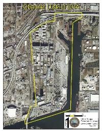
Begin at the intersection of the Northerly projection of the Centerline of Channelside Drive (Thirteenth Street) and the Centerline of Adamo Drive (S.R. 60) (First Avenue) as shown on TAMPA DOCK CO'S. ESTUARY SUBDIVISION NO. 2, a subdivision of record in Plat Book I 1. Page 95 of the public records of Hillsborough County, Florida;run thence Easterly along said Centerline of Adam Drive to its intersection with the Northerly projection of the Easterly boundary of the following described tract: Tract beginning on the South Right of Way line of Adamo Drive a distance of 443.80 feet East of the East Right of Way line of 14th Street and run East 390.94 feet; thence South 02°16' 19" West a distance of 204.51 feet; thence South 56° 02'33" West a distance of 171.71 feet; thence North 88° 09'38" West a distance of 250.00 feet, to a point lying 294.96 feet South of the point beginning; thence North 01'° 50'22" East, a distance of 294.96 feet to the Point of Beginning, less Right of Way for Expressway, as shown by the Tampa Hillsborough County Expressway Authority, on their drawings prepared by Greiner Engineering, and titled Tampa South Crosstown Expressway Eastern Extension to I-75, project number 10002-2520-035, Sheet No. 3; run thence Southerly along said Northerly projection and Easterly boundary of said described tract, to and along its Southeasterly projection, to its intersection with the Centerline of Ybor Channel, said Centerline being that between the Easterly and Westerly combined Pierhead and Bulkhead Lines of said Channel as determined by the Jacksonville District, Corps of Engineers of the Department of the Army and shown on their drawing of the U.S. Harbor Lines, Tampa Harbor, Florida Hillsborough River and Hillsborough Bay Sheet No. 2, File 45-20,641; run thence Southerly along said Centerline to its intersection with the Easterly Projection of the Centerline of Garrison Channel per the Tampa Port Authority Bulkhead Lines as established by Hillsborough County Port Authority on September 15, 1960 and filed for record in Plat Book 42, Page 37 of the public records of Hillsborough County,Florida, said Centerline lying, 150 feet Northerly of and parallel to that combined Pierhead and Bulkhead Line forming the Northerly boundary of Seddon Island (Harbour Island), and lying between the U.S. Corps of Engineers Harbour Line Monuments THL214 and THL 215; run thence Southwesterly along said Centerline to its intersection with the Southwesterly projection of the Easterly boundary of Water Lot 70 of HENDRY & KNIGHT'S MAP OF CHAMBERLAINS, a subdivision of record in Plat Book 5, Page 10 of the public records of Hillsborough County, Florida; run thence Northeasterly along said projection, Easterly boundary, and its Northeasterly projection to the Easterly projection of the Centerline of Channelside Drive ( Carew Avenue, Platt Street), as shown on said HENDRY KNIGHT'S MAP OF CHAMBERLAINS; run thence Easterly along said projection and Centerline to its intersection with the Southeasterly projection of the Westerly boundary of Meridian Avenue (Wiggins Avenue), as shown on said HENDRY &, KNIGHT'S MAP OF CHAMBERLAINS ; run thence Northwesterly along said projection and boundary, and its Northwesterly projection, to and along the Westerly boundaries, and their Northwesterly projections of Meridian Avenue (Unnamed per plat)as shown on MAP OF FINLEY AND CAESAR SUBDIVISION, as recorded in Plat Book 1, Page 84 of the public records of Hillsborough County, Florida, Meridian Avenue(Maxwell Avenue) as shown on MAP OF FINLEY AND STILLINGS SUBDIVISION, as recorded in Plat Book 1, Page 88 of the public records of Hillsborough County, Florida,and Meridian Avenue, as shown MAP OF FINLEY AND JONES SUBDIVISION, as recorded in Plat Book 1, Page 93 of the public records of Hillsborough County, Florida,to its intersection with the Southwesterly projection of the Southeasterly Limited Access Right of Way line of said Tampa South Crosstown Expressway Eastern Extension to I-75; run thence Northeasterly along said projection and Limited Access Right of Way line,and its Northeasterly projection, to its intersection with the Centerline of Channelside Drive (Thirteenth Street); run thence Northerly along said Centerline and its Northerly projection to its intersection with the Centerline of Adamo Drive (First Avenue), said intersection being the Point of Beginning.