Begin at the center point of the intersection of the Right-Of-Way-Lines of Tampa Street and Palm Avenue, run thence West, along the center line of the Palm Avenue Right-Of-Way line to the center point of the 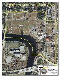
intersection of the Right-Of-Way Lines of Palm Avenue and Highland Avenue; thence run North along the center line of Highland Avenue to the center point of the intersection of the Centerlines of Ross Avenue and Highland Avenue; thence run West along the Centerline of the Ross Avenue Right-of-Way to the center point of the intersection of Ross Avenue and North Boulevard; thence run South along the center line of the North Boulevard Right-of-Way to the intersection of the North Boulevard Right-of- Way and the Centerline of the Hillsborough River (said centerline being equidistant from opposing mean high water lines as established by the U.S. Army Corps of Engineers); thence run East/Southeast along said centerline of the Hillsborough River to the intersection of the centerline of the Hillsborough River and the Northern Limited Access Right-of-Way line of Interstate-275; thence run East along the Northern Right-of-Way line of Interstate-275, to the Center point of the intersection of Interstate-275 and Tampa Street; and Tampa Street thence run North along the center line of Tampa Street to the intersection of the Right-Of-Way lines of Tampa Street and Palm Avenue and the Point of Beginning; all of the area previously described is located within Section 13, Township 2 9 South, Range 18 East, City of Tampa, Hillsborough County, Florida; containing 77.04 acres, more or less.